APPLICATIONS OF TECHNOLOGY:

Imaging hydrocarbon reservoirs
- Improving seismic survey acquisition planning
- Forward-model seismic wave propagation in large-scale 2-D geological models
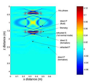
- Model borehole wave propagation for vertical seismic profile (VSP) and cross-well surveys
- Improved computational efficiency enables more realistic geological modeling
- Assisting interpretation of data from complex environments
- Model seismic wave propagation through complex anisotropic and fractured media
- Investigate the effects of strong contrasts in material properties of boreholes, faults, fractures, marine and soft sediment layers
ADVANTAGES:
- Computationally efficient
- Reduces memory use and increases speed via variable grid spacing
- Fully parallelized and portable
- Avoids unnecessary computation by restricting the wavefield update to gridpoints inside an expanding surface defined by the maximum seismic velocity
- Anisotropic: offers isotropic, vertical axis of symmetry (VTI), orthorhombic, and Tilted Transverse Isotropy (TTI) modeling
- Fractures can be modeled discretely or as equivalent anisotropic media
- Software is compatible with Berkeley Lab’s GEM graphical model-building tool
ABSTRACT:
Berkeley Lab’s AnisWave2D software is computationally-efficient, fully anisotropic finite-difference code for modeling seismic wave propagation in complex media like that surrounding hydrocarbon reservoirs.
Most hydrocarbon reservoirs are overlain by low seismic velocity and anisotropic sediments whose effects on the wavefield must be considered in order to successfully image deeper structures. Conventional uniform-grid finite-difference (FD) schemes running on a single processor cannot tackle large-scale anisotropic models with realistic velocity structure. AnisWave’s use of variable grid spacing improves the efficiency of the FD method by avoiding the oversampling of high velocity zones that occurs in uniform grid methods. This enables more efficient modeling of materials with strong velocity contrasts, such as boreholes, fractures and soft marine sediments. The use of variable-gridding combined with parallelization and optimization of the code greatly increases the complexity of the problems that can be tackled, without sacrificing accuracy.
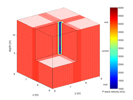
Geometry of a single-well survey. Fine grid spacing is used around the low velocity borehole.
STATUS:
- Copyrighted. Available for licensing.
REFERENCE NUMBER: CR-1878, 2089
SEE THESE OTHER BERKELEY LAB TECHNOLOGIES IN THIS FIELD:
- EM3D: Risk Minimizing Software for Finding Fossil Fuels by Fluid Identification, IB-2265
- Gas Exploration Software for Reducing Uncertainty in Gas Concentration Estimates, CR-2342

- Geophysical Earth Modeling (GEM) Software, IB-1613
- Wellbore Procedure Characterizes Groundwater Contamination, CR-1256

